Myths about teaching can hold you back
- Year 6
Longitude and time zones
I can identify the Prime Meridian and understand time zones.
- Year 6
Longitude and time zones
I can identify the Prime Meridian and understand time zones.
These resources were made for remote use during the pandemic, not classroom teaching.
Switch to our new teaching resources now - designed by teachers and leading subject experts, and tested in classrooms.
Lesson details
Key learning points
- Time zones to the east of the Prime Meridian are ‘UTC (or GMT) plus’; time zones to the west are ‘minus UTC (or GMT)'.
- Webcams are a useful source of information about what is happening in places which are in different time zones.
- Earth is divided into 24 standard meridians, at intervals of 15˚, which are the basis for delineating 24 time zones.
- Time zones are measured from the Prime Meridian at 0˚ longitude, where the time is Universal Co-ordinated Time (UTC).
Keywords
Co-ordinated Universal Time - Co-ordinated Universal Time (UTC) is a standard system that is used to set all the world’s time zones.
Greenwich Mean Time - Greenwich Mean Time (GMT) is the time at the zero degree line of longitude, also known as the Prime Meridian.
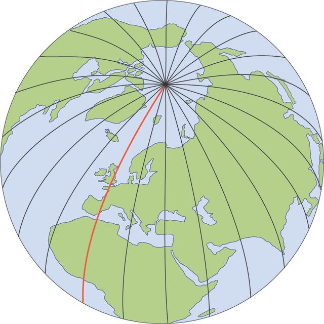
Prime Meridian - The Prime Meridian is the line of longitude at 0 degrees, from which the other lines of longitude are measured east and west.
Common misconception
UTC and GMT are the same.
UTC is a time standard - an agreement to synchronise the worlds timings centres to this standard time. GMT is a time zone.
To help you plan your year 6 geography lesson on: Longitude and time zones, download all teaching resources for free and adapt to suit your pupils' needs...
To help you plan your year 6 geography lesson on: Longitude and time zones, download all teaching resources for free and adapt to suit your pupils' needs.
The starter quiz will activate and check your pupils' prior knowledge, with versions available both with and without answers in PDF format.
We use learning cycles to break down learning into key concepts or ideas linked to the learning outcome. Each learning cycle features explanations with checks for understanding and practice tasks with feedback. All of this is found in our slide decks, ready for you to download and edit. The practice tasks are also available as printable worksheets and some lessons have additional materials with extra material you might need for teaching the lesson.
The assessment exit quiz will test your pupils' understanding of the key learning points.
Our video is a tool for planning, showing how other teachers might teach the lesson, offering helpful tips, modelled explanations and inspiration for your own delivery in the classroom. Plus, you can set it as homework or revision for pupils and keep their learning on track by sharing an online pupil version of this lesson.
Explore more key stage 2 geography lessons from the Time zones: can we time travel on planet Earth? unit, dive into the full primary geography curriculum, or learn more about lesson planning.

Equipment
Devices to access the internet to investigate live city webcams.
Licence
Prior knowledge starter quiz
6 Questions
Q1.A is a map of Earth on a sphere.
Q2.Lines of longitude are imaginary lines on Earth showing position east or west of the , measured in degrees.
Q3.At any moment, half of Earth faces the sun and experiences the light and heat from the sun’s rays while the other half is in ...
Q4.Which statements about lines of longitude are true?
Q5.What is the name given to the red line of longitude shown on this globe?

Q6.The Antimeridian is located at longitude and runs through the Pacific Ocean.
Assessment exit quiz
6 Questions
Q1.Daylight happens when places face towards the ...
Q2.Greenwich Mean Time (GMT) is the average time when the sun crosses the at Greenwich in London.
Q3.Which of these is a standard system that is used to set all of the world’s time zones?
Q4.Time in countries to the east of the Prime Meridian is always that in the UK.
Q5.Time in countries to the west of the Prime Meridian is always ...
Q6.If the UTC was 12:00 noon, which time zone do you think this webcam could be from?


