Myths about teaching can hold you back
- Year 5
Mapping changes in forests around the world
I can research the significance of forests to local communities.
- Year 5
Mapping changes in forests around the world
I can research the significance of forests to local communities.
These resources were made for remote use during the pandemic, not classroom teaching.
Switch to our new teaching resources now - designed by teachers and leading subject experts, and tested in classrooms.
Lesson details
Key learning points
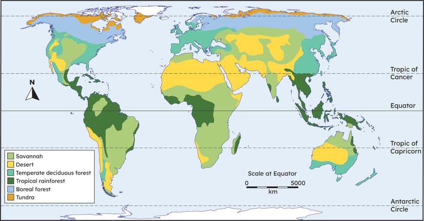
- Maps can give us information about the location and extent of forests globally.
- Some parts of the world, such as the Amazon, are experiencing deforestation.
- Satellite imagery can be used to identify how much deforestation has happened.
- Deforestation impacts on local and global communities in many different ways.
Keywords
Indigenous - Indigenous describes people who are the original inhabitants of a place, rather than people who moved there from somewhere else
Hectare - A hectare is a measurement of land. Each hectare is 10,000 square metres
Satellite image - A satellite image is a photograph taken from high above using a satellite
Deforestation - Deforestation is the complete removal of trees
Common misconception
Trees are a renewable resource and can just be cut down then replanted without any negative impact.
It can take hundreds of years for some woodland to become established with the same benefits. It is important to protect the global forests that we currently have.
To help you plan your year 5 geography lesson on: Mapping changes in forests around the world, download all teaching resources for free and adapt to suit your pupils' needs...
To help you plan your year 5 geography lesson on: Mapping changes in forests around the world, download all teaching resources for free and adapt to suit your pupils' needs.
The starter quiz will activate and check your pupils' prior knowledge, with versions available both with and without answers in PDF format.
We use learning cycles to break down learning into key concepts or ideas linked to the learning outcome. Each learning cycle features explanations with checks for understanding and practice tasks with feedback. All of this is found in our slide decks, ready for you to download and edit. The practice tasks are also available as printable worksheets and some lessons have additional materials with extra material you might need for teaching the lesson.
The assessment exit quiz will test your pupils' understanding of the key learning points.
Our video is a tool for planning, showing how other teachers might teach the lesson, offering helpful tips, modelled explanations and inspiration for your own delivery in the classroom. Plus, you can set it as homework or revision for pupils and keep their learning on track by sharing an online pupil version of this lesson.
Explore more key stage 2 geography lessons from the Local and global: why are trees and forests important? unit, dive into the full primary geography curriculum, or learn more about lesson planning.

Licence
Prior knowledge starter quiz
6 Questions
Q1.Climate zones are areas that have similar .
Q2.Match the key word to its definition.
trees and shrubs that keep their leaves all year round
trees and shrubs that lose all their leaves in autumn and winter
those already growing in a place and not introduced there by humans
Q3.What is the boreal forest climate like?
Q4.The most common boreal tree species are deciduous and evergreen conifers such as:
Q5.Which continent does not contain any temperate deciduous forest?


